Key Findings
On 20 October 2025, sites within the urban area of (Kabkabiya) in (North Darfur) were subjected to an aerial attack using a drone, as documented and analysed by the Dalil Team based on open-source materials.
The strike targeted a location containing civilian facilities, including the local police headquarters and the adjacent educational facility (Industrial School), as verified by the Dalil Team through analysis of visual evidence and satellite imagery.
The town of (Kabkabiya) has been under the control of the Rapid Support Forces (RSF) since 15 April 2023, following the withdrawal of the Sudanese Armed Forces, and remains under their control at the time of reporting.
The attack resulted in civilian casualties (with no confirmed figures available), in addition to significant material damage affecting buildings and vehicles within the site.
Visual materials analysed by the Dalil Team show the presence of armed elements within the civilian site at the time of the attack, reflecting a mixed operational environment that increases the risk of harm to civilians.
Introduction
Information collected and analysed by the Dalil Team, including content published by Darfur Victims Support , indicates that a drone, reportedly operated by the Sudanese Armed Forces (SAF), carried out a strike targeting the local police headquarters in (Kabkabiya) at approximately 12:00 PM local time.
At the time of writing, no confirmed figures regarding casualties were available.
A video analysed by the Dalil Team shows thick plumes of smoke rising from the targeted location, reflecting the intensity of the explosion.
The footage also documents the presence of armed individuals within the site, indicating an operational environment in which civilian objects are intermingled with military presence.
In a separate statement, the Rapid Support Forces reported that drone attacks launched from an “external base” targeted populated areas in (Zalingei) and (Kabkabiya), resulting in civilian casualties, and attributed responsibility to the Sudanese Armed Forces (SAF) and their allies.
Geolocation Verification
The Dalil Team conducted a detailed geolocation verification based on analysis of video footage and comparison with satellite imagery, successfully identifying the strike location at the following coordinates (N,24°05’02.53” E”49.74’38°13)
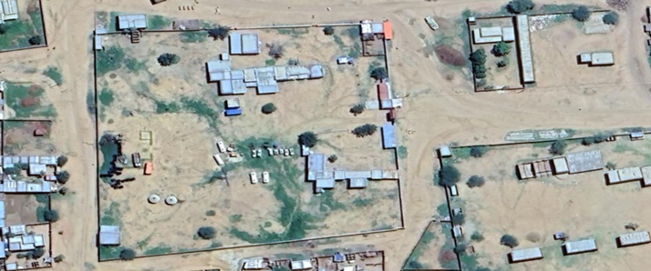
The town of (Kabkabiya) is located approximately 155 kilometres west of (El Fasher), within (North Darfur), and has been under the control of the Rapid Support Forces since 15 April 2023. The Dalil Team’s analysis indicates that the area has experienced a noticeable escalation in aerial attacks in recent periods, including the present incident, which occurred days after similar shelling.
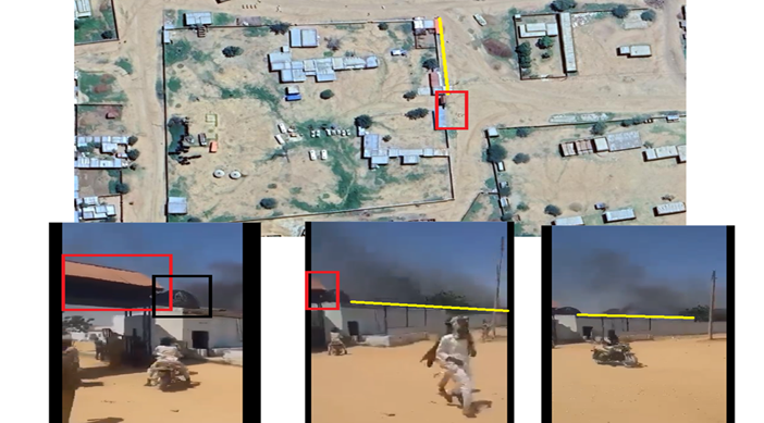
The Dalil Team relied on matching visual landmarks in the footage with satellite imagery using (Google Earth) analysing (Building patterns within the site, Distribution of urban structures, Road directions and surrounding pathways, Visual characteristics of the site and its environment)
This analysis demonstrated a precise match between the video content and the identified geographic location, which includes an urban area comprising (The local police headquarters in Kabkabiya and The adjacent industrial school.
The Dalil Team further corroborated this identification through analysis of satellite imagery from the (Copernicus) App, which showed damage at the same coordinates. This was established by comparing an image captured on 17 October 2025 (pre-strike) with a subsequent image dated 22 October 2025 (post-strike), where clear indicators of structural damage were observed.
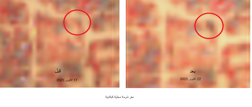
This temporal and spatial correlation, as analysed by the Dalil Team, reinforces the accuracy of the strike location and its consistency with available visual and chronological evidence.
Damage Analysis
The Dalil Team’s analysis of visual evidence and satellite imagery indicates that the attack caused direct and significant damage within the targeted site.
The video documents the emergence of dense smoke from within the area, suggesting the occurrence of a high-impact explosion.
Satellite imagery comparison before and after the strike reveals clear structural changes in the site, including damage to the police headquarters and the adjacent educational facility, as well as indications of destroyed or damaged vehicles within the same area.
The distribution of damage, as assessed by the Dalil Team, suggests that the impact was not confined to a narrowly defined target point but extended across multiple elements within a civilian environment. This supports the conclusion that the material effects of the strike impacted inherently civilian objects.
Context and Evidence Analysis
The Dalil Team’s analysis reveals a complex operational environment in which civilian presence is intermingled with armed elements within the same spatial area.
The video footage shows individuals believed to be affiliated with the Rapid Support Forces present within the site at the time of the strike, indicating a potentially mixed use of the location.
From an analytical perspective, this overlap raises questions regarding the nature of the target, as the presence of armed elements may influence its characterization.
However, such presence does not negate the civilian status of the site, nor the legal protections afforded to civilian objects.
More broadly, this incident forms part of a wider pattern of aerial attacks targeting populated areas in (North Darfur), as documented by the Dalil Team through the analysis of similar incidents in this period.
This pattern reflects an increasing reliance on means of warfare with wide-area effects in civilian environments, thereby heightening the risk of significant harm.
The consistency between visual evidence, geolocation findings, and statements from relevant actors further strengthens the reliability of the factual reconstruction of the incident.
Evidence-Based Findings
The evidence analysed by the Dalil Team confirms that the strike occurred within a clearly defined urban civilian area containing administrative and educational facilities.
Satellite imagery and video evidence indicate that the damage directly affected the police headquarters, the adjacent educational facility, and vehicles within the site.
The pattern of damage suggests that the impact was not limited to a narrowly defined target but extended across a civilian environment, reflecting a relatively wide-area effect.
The evidence documents the presence of armed elements within the site at the time of the attack, indicating a potentially mixed use of the location.
Geolocation, satellite imagery analysis, and visual evidence are consistent with multiple accounts indicating that the strike occurred in a populated area.
Legal Assessment
The evidence-based findings indicate a potential direct impact on civilian objects, raising questions regarding compliance with the principle of distinction between civilian and military targets.
The documented extent of damage raises serious concerns regarding adherence to the principle of proportionality, particularly if the anticipated civilian harm exceeded the expected military advantage.
The presence of armed elements within the site may suggest potential military use of civilian objects however, this does not relieve parties of their obligation to take all
The nature of the strike within a populated area raises additional concerns regarding compliance with the obligation to take precautions in attack.
Accordingly, the findings of the Dalil Team point to a real risk of potential violations of international humanitarian law, particularly with respect to the protection of civilians and civilian objects.