Key Findings
The Dalil Team identified damage and disruption affecting four key components of the water supply system serving (El Obeid): (Barbar), (Wad Al-Baqa), (Al-Dankoj) and (Al-Sidr). The affected infrastructure included water reservoirs, pumps, wells, transmission lines and associated operational facilities.
The Dalil Team verified the locations of several facilities and related damage through open-source geolocation and visual analysis, matching features visible in video footage with satellite imagery available through Google Earth and comparing imagery captured on different dates through Copernicus and Planet.
Satellite imagery showed a significant decline in water levels at (Barbar) and (Wad Al-Baqa) during the period analysed, accompanied by visible indicators of reduced vegetation cover and declining water replenishment.
Open-source evidence indicates that two factors affected the water system simultaneously: declining water availability associated with reduced rainfall, and damage or disruption affecting infrastructure involved in water production, pumping and transmission.
Media sources reported in July 2026 that the water supply deficit in (El Obeid) had reached approximately 70% after several major sources and facilities went out of service.
Available evidence indicates that (El Obeid) relies on a limited number of principal water sources, making the disruption of any one source or associated facility capable of directly affecting the volume of water supplied to the city.
The available open-source evidence does not allow all damage to the water system to be conclusively attributed to a single party. The report therefore distinguishes between damage observed or independently verified by the Dalil Team and claims made by external sources regarding responsibility.
Background
(El Obeid), the capital of (North Kordofan) State, relies on a network of water sources and facilities within and around the city to meet the population’s water needs.
The system includes reservoirs, surface-water sources, wells, pumping stations and transmission lines connecting water sources with treatment and distribution facilities supplying the city.
In June 2024, Atar magazine documented the (Barbar) station as part of the southern water sources supplying (El Obeid), reporting that the total storage capacity of the southern sources was approximately 21 million cubic metres.
During 2025 and 2026, continuing military operations in (North Kordofan) coincided with a visible decline in water levels at some of these sources. In July 2026, media reports indicated that several principal water sources had gone out of service and that the water supply deficit in (El Obeid) had widened to approximately 70%.
The Dalil Team analysed visual material, satellite imagery and published information concerning four locations associated with the water system—(Barbar), (Wad Al-Baqa), (Al-Dankoj) and (Al-Sidr)—to establish their locations and assess changes and damage affecting them during the period under investigation.
(Barbar) Reservoirs – North Kordofan
On 10 July 2026, the Kordofan 24 platform reported that the (Barbar) reservoirs required maintenance and stated that repairing the damage could help close part of the water supply gap in (El Obeid).
According to the source, the reservoirs contained water but required pumping engines and machinery, while the transmission lines running from (Barbar) to (Wad Al-Baqa) and the treatment station also required maintenance.
Atar magazine had previously documented the (Barbar) station in June 2024 as part of the southern water sources serving (El Obeid), reporting a combined storage capacity of approximately 21 million cubic metres for the southern sources.
On 24 July 2026, Xinhua reported that 15 civilians had been killed and seven others injured in an attack on the (Barbar) area south of (El Obeid), which the Government of (North Kordofan) attributed to the Rapid Support Forces.
Four days later, on 28 July 2026, Radio Dabanga reported that the Rapid Support Forces controlled the (Barbar) reservoir and the southern water sources in the context of military operations and the siege of (El Obeid).
Geolocation and Evidence Analysis
The Dalil Team identified the location of the (Barbar) reservoirs at:
12.816574856875826, 30.32079330901762
The Team compared satellite imagery available through Copernicus from 18 September 2025 and 4 August 2026.
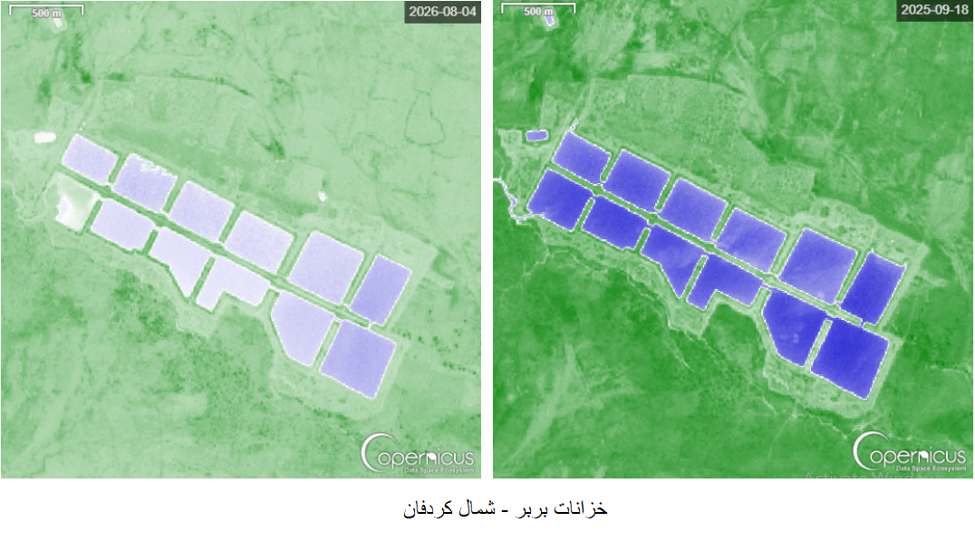
The comparison showed a sharp decline in the reservoirs’ water levels during the period analysed, coinciding with indicators of reduced rainfall and declining water replenishment.
To assess these changes in greater detail, the Dalil Team analysed high-resolution Planet satellite imagery, comparing an image captured on 31 August 2025 with another captured on 20 August 2026.
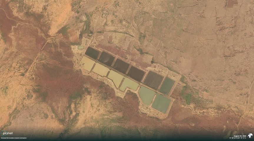
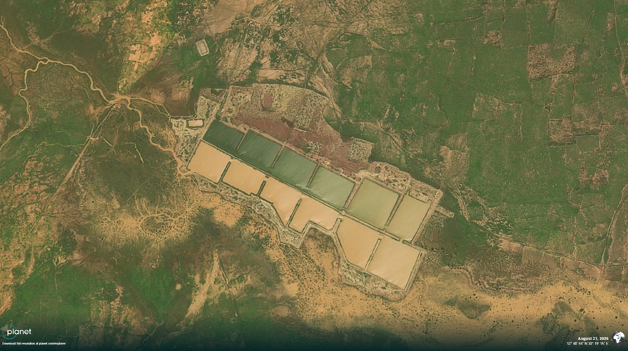
The comparison showed a clear contraction in the water surface and a decline in surrounding vegetation, demonstrating a significant change in the hydrological and environmental condition of the site compared with the previous year.
Satellite imagery alone cannot conclusively establish the cause of the decline, but it clearly documents a substantial reduction in water levels during the period under comparison.
Wad Al-Baqa Reservoirs – North Kordofan
On 12 June 2026, the Rapid Support Forces (RSF) stated that the Wad Al-Baqa reservoirs had been attacked by drones and attributed the attack to the Sudanese Armed Forces (SAF).
The Dalil Team found no independent evidence among the open sources reviewed that would allow it to corroborate this account or independently determine responsibility for the attack.
On 17 July 2026, Sudan Tribune cited officials from the El Obeid Water Authority as saying that pumps installed at the Wad Al-Baqa reservoirs had been targeted by drones, disrupting water supplies to the southern neighbourhoods of El Obeid.
According to the source, the loss of these facilities, alongside the disruption of other water sources, contributed to widening the city’s water supply deficit to approximately 70%.
Satellite Imagery Analysis
The Dalil Team tracked changes at the Wad Al-Baqa reservoirs, located at the coordinates: 12.978954127530795, 30.350650087479682
The Team analysed a time series of satellite imagery available through Copernicus, including images captured on 5 December 2025, 9 January, 8 February, 5 March, 6 April, and 17 August 2026.
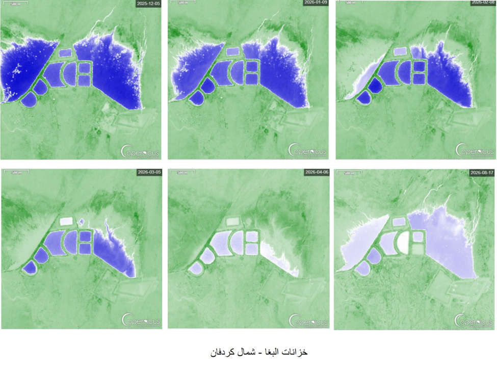
A sequential comparison of these images showed a gradual decline in the surface area of water within the reservoirs over the period analysed.
This decline occurred in the context of indicators of reduced rainfall and declining water replenishment, suggesting increasing pressure on the source as available water resources diminished.
Analysing a sequence of satellite images captured on successive dates provides a clearer picture of the progression of this decline than a comparison between two individual dates.
The imagery shows a gradual contraction of the water-covered area within the reservoirs between December 2025 and August 2026.
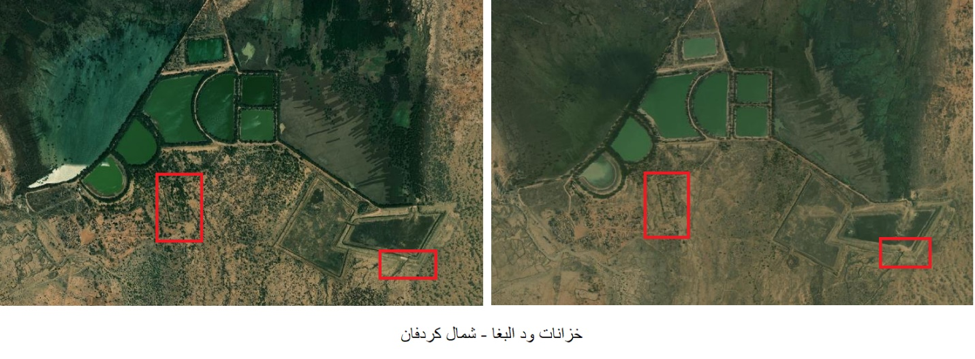
To further assess these changes, the Dalil Team reviewed high-resolution Planet satellite imagery, comparing an image captured on 19 December 2025 with another captured on 19 August 2026.
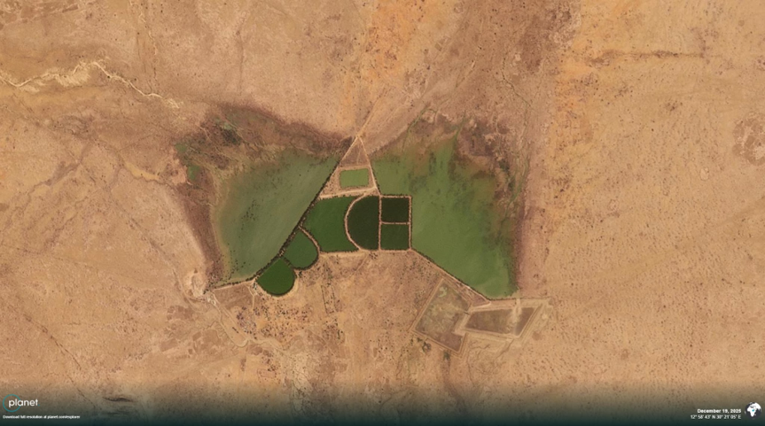
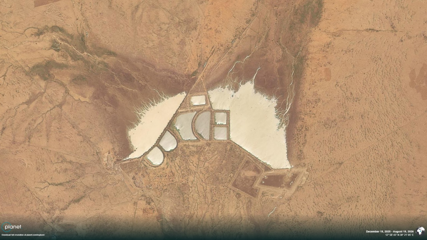
The comparison showed clear indicators of declining water levels and receding vegetation around the reservoirs, with a noticeable reduction in the water surface area in the August 2026 image compared with the December 2025 image.
The changes visible in the Planet imagery are consistent with the gradual trend identified through the Copernicus time series, providing an additional source of visual evidence supporting the observed decline in water levels and vegetation cover at the Wad Al-Baqa reservoirs during the period under analysis.
Damage to Surrounding Infrastructure
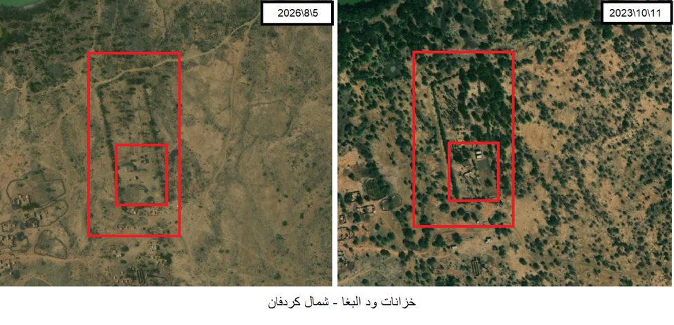
In addition to monitoring changes in water levels, the Dalil Team identified indicators of damage to several buildings and structures surrounding the reservoirs in Copernicus satellite imagery from 5 August 2026.
The observed damage appears within a period following reports that pumps and facilities associated with the Wad Al-Baqa reservoirs had been targeted by drones in June 2026.
Similarly, the observed decline in the reservoirs’ water surface cannot be directly attributed to the damage affecting surrounding infrastructure.
The Copernicus time series, supported by high-resolution Planet imagery, indicates that water levels declined progressively in a context marked by indicators of reduced rainfall and declining water replenishment.
The Wad Al-Baqa case therefore demonstrates the simultaneous impact of two distinct factors on the water supply system.
The first is the gradual decline in available water resources within the reservoirs, occurring alongside reduced rainfall and water replenishment.
The second is damage affecting infrastructure and operational components associated with the water source, including pumps that, according to published sources, supplied the southern neighbourhoods of El Obeid.
These developments form part of a broader context in which the principal water sources south of El Obeid came under simultaneous pressure during 2026, including declining water resources, damage to pumping and transmission infrastructure, and reported military attacks affecting facilities associated with the water supply system.
Taken together, the available evidence indicates that the water crisis in El Obeid did not result from a single factor.
Rather, declining water resources coincided with disruption and damage affecting parts of the infrastructure used to pump and transport water, contributing to a reduction in the system’s capacity to provide adequate supplies to the city’s population.
(Al-Dankoj) Water Station
On 27 December 2025, military clashes broke out in the (Al-Dankoj) area between the Sudanese Armed Forces and the Rapid Support Forces.
Military sources reported the use of artillery shelling and drones in the area, while Darfur24 highlighted the strategic importance of (Al-Dankoj) because it contains one of the principal water stations supplying (El Obeid).
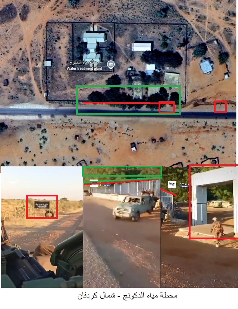
Video footage broadcast by Al Arabiya also showed Rapid Support Forces personnel inside the (Al-Dankoj) area.
Geolocation
The Dalil Team analysed visual features visible in the footage and compared buildings, roads and other fixed elements with satellite imagery available through Google Earth.
The Team matched several visual features, supporting the identification of the filming location within (Al-Dankoj), near the water station, at:
13.463346098936729, 30.305424687471476
The geolocation supports the presence of Rapid Support Forces personnel in the area where the water station is located during the period documented by the footage.
The video itself, however, does not establish that the force visible in the footage was responsible for damage to the facility.
On 7 August 2026, Sudan Independent reported that water-sector teams had inspected damage in both (Al-Sidr) and (Al-Dankoj). The report stated that water infrastructure had been vandalised, including electrical cables, copper components, pumps and other equipment, in addition to damage affecting stations and wells.
(Al-Sidr) Water Station – North Kordofan
The (Al-Sidr) area constitutes one of the principal water sources associated with the system supplying (El Obeid).
On 17 July 2026, Sudan Tribune reported that the city’s principal water sources had gone out of service, including the (Al-Sidr) basin, contributing to a water supply deficit of approximately 70% in (El Obeid).
On 7 August 2026, Sudan Independent reported that water-sector teams had inspected damage to water facilities in the (Al-Sidr) and (Al-Dankoj) areas.
According to the report, the damage included vandalised electrical cables, copper components, pumps and other equipment, as well as damage to stations and wells. The authorities were also reported to be preparing to restart the (Al-Sidr) wells and restore water supply.
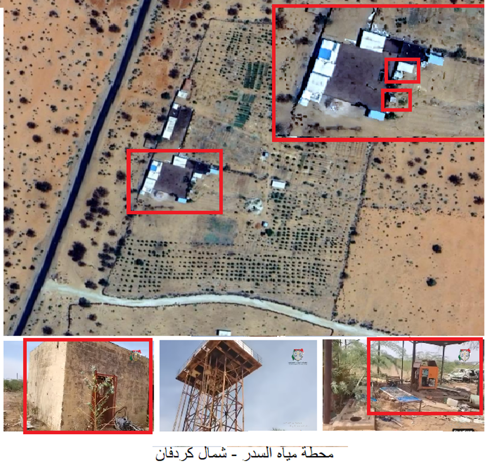
On 10 August 2026, a video emerged documenting vandalism and damage affecting the (Al-Sidr) station.
Geolocation
The Dalil Team analysed the prominent visual features appearing in the footage and compared them with satellite imagery available through Google Earth.
The comparison showed correspondence between the buildings and other fixed elements visible in the footage and the geographic location of the (Al-Sidr) station, confirming that the facility shown in the video is located at:
13.634208948257458, 30.348174634021206
Damage Analysis
In addition to verifying the location of the video, the Dalil Team compared satellite imagery available through Copernicus, using an image captured on 28 December 2025 and another captured on 5 August 2026.
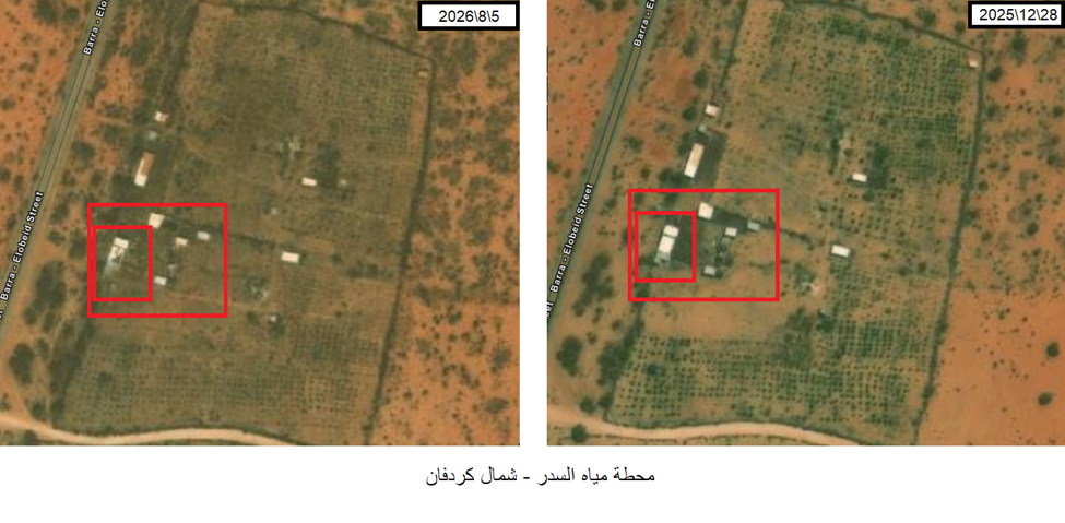
The comparison showed visible changes and damage affecting structures at the station during the period between the two images.
These changes provide independent supporting evidence, alongside the video footage and published information, that physical damage occurred at the (Al-Sidr) station during the period under investigation.
Analysis of the Water Supply System
The evidence collected and analysed by the Dalil Team indicates that the water system serving (El Obeid) was subjected to simultaneous pressures from more than one factor.
At (Barbar) and (Wad Al-Baqa), satellite imagery documents a clear decline in water surface area and surrounding vegetation, coinciding with indicators associated with reduced rainfall and declining water replenishment.
At the same time, visual material, published sources and satellite imagery indicate damage and disruption affecting operational water infrastructure at (Al-Dankoj) and (Al-Sidr), including, according to published reports, pumps, electrical cables, wells and other operational components.
Published information concerning the need for pumping equipment and repairs to transmission lines at (Barbar) further indicates that the physical availability of water at a source does not necessarily mean that it can be delivered to the city when pumping, transmission or treatment components are out of service.
Taken together, these findings demonstrate the vulnerability of a system dependent on a limited number of principal sources and associated operational facilities. A decline in water availability at one source, or disruption to a pumping station or transmission line, can directly affect the volume of water reaching residents of (El Obeid).
Evidence-Based Findings
The Dalil Team verified the location of the (Barbar) reservoirs, where satellite imagery showed a substantial decline in water levels and surrounding vegetation between 2025 and 2026.
Planet imagery showed a significant reduction in water surface area and vegetation at the (Wad Al-Baqa) reservoirs between December 2025 and August 2026.
The Dalil Team geolocated video footage showing Rapid Support Forces personnel inside the (Al-Dankoj) area near the water station. The footage, however, is not sufficient on its own to attribute damage to the station to the force visible in the recording.
Published sources reported damage and vandalism affecting water infrastructure in (Al-Dankoj) and (Al-Sidr), including electrical cables, copper components, pumps, equipment, stations and wells.
The Dalil Team verified the location of video footage documenting damage at the (Al-Sidr) station, while an independent comparison of Copernicus satellite imagery confirmed changes and damage affecting the facility between December 2025 and August 2026.
Published reporting indicates that several principal water sources serving (El Obeid) went out of service and that the city’s water supply deficit reached approximately 70% in July 2026.
The available evidence indicates that the water crisis cannot be explained by a single factor. Declining water resources coincided with damage and disruption affecting infrastructure used to produce, pump and transport water.
The evidence available to the Dalil Team does not allow all damage affecting the water system to be independently and conclusively attributed to a specific party.
Legal Assessment
Water production, pumping and transmission facilities perform an essential function in supplying water to the civilian population. Damage to reservoirs, wells, pumping stations and transmission lines can therefore have consequences extending beyond the physical facilities themselves, directly affecting civilians’ access to water.
This is particularly significant in the case of (El Obeid), given reports that the water supply deficit reached approximately 70% and that several principal sources had gone out of service.
Under international humanitarian law, civilian objects are protected from attack unless and for such time as they become military objectives under the applicable legal criteria. The rules governing the conduct of hostilities also require distinction between military objectives and civilian objects and the adoption of precautions aimed at limiting harm to civilians and the infrastructure upon which they depend.
However, the evidence collected and verified by the Dalil Team in this investigation does not establish the circumstances surrounding all damage affecting the water facilities, demonstrate that all such damage resulted from military attacks, or conclusively identify those responsible.
Any determination of legal responsibility for specific incidents would therefore require additional evidence concerning the timing and cause of the damage, the nature and use of the relevant facility at the time of the incident, the actor responsible for the conduct, and the surrounding military circumstances.